East Water and Environmental Research Institute (EWERI)
05138337281
info@eweri.ir
telegram
linkedin-1
researchgate
  • home
  • About Eweri
    • About us
    • Organizational chart
    • Staff
    • collaborators
  • Departments
    • Hydroinformatics
    • Remote Sensing and Environmental science
  • Events
  • Projects
  • faPersian
لوگو مرکزموسسه پژوهشی زیست شرق

Identifying the regions with geogenic pollution risk of toxic metals in groundwater using geostatistical models and artificial intelligence methods

مرداد ۲۰, ۱۳۹۸Projects, پروژه هاNo Commentsadmin

Identifying the regions with geogenic pollution risk of toxic metals in groundwater using geostatistical models and artificial intelligence methods; A case study: Razavi Khorasan Province

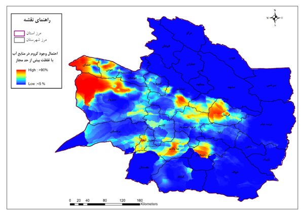
Groundwater is the main source of water for drinking and irrigation in the arid and semi-arid regions of Iran. Information on spatial variation in groundwater quality and modelling large scale groundwater geogenic contamination are crucial for management of the available water resources. This study evaluated the spatial distribution of various chemical parameters of groundwater, including heavy metals, in Khorasan province, Iran.

Client(s)

Iran National Science Foundation (INSF)

Duration

2019-2020

Contact

Ata Joodavi

Progress 50%
50%
Next post Hydrogeology, conceptual and numerical models of groundwater in Mashhad aquifer

Leave a Reply Cancel reply

Your email address will not be published. Required fields are marked *

1 × one =

News

  • Hydrogeology, conceptual and numerical models of groundwater in Mashhad aquifer
  • Identifying the regions with geogenic pollution risk of toxic metals in groundwater using geostatistical models and artificial intelligence methods

Eweri-Your Contact

P.O. box 918873717, Mashhad, Razavi Khorasan Province, Iran
(+98) 5138337281
(+98) 5138337281
info@eweri.ir
© 2017 تمامی حقوق برای موسسه پژوهشی آب و محیط زیست شرق محفوظ است